Metro View
 Metro View is a unique, regional information and analysis system. Its purpose is to provide citizens, political decision makers, businesses and investors with a holistic, yet highly detailed picture of how the region — the 17-jurisdiction Richmond Metropolitan Statistical Area — really works. By providing information in several formats and by organizing various opportunities for community discussion and engagement about regional issues, Metro View will contribute to the creation of a “culture of metropolitanism” in the Richmond region.
As this culture develops, citizens, decision makers and investors will become more accustomed to thinking regionally and this will enable them to address issues of a regional nature in a proactive, positive fashion. Local political boundaries will, of course, remain, but people will be increasingly able to look across them to address issues that require regional approaches. Leaders who wish to approach regional issues with solid information will increasingly consult Metro View as their main source. The result will be a region that is more productive, globally competitive and fiscally healthy, and which enjoys a high quality of life.
Metro View consists of two components — technical and social. The technical component involves the collection of so-called “micro-data” — data that are not readily available and which require laborious effort to collect, clean and enter into useful databases — as well as data that are more readily available, and the aggregation and analysis of these data in a way that can inform decision making. The social part of Metro View involves the dissemination of the analyses through vehicles that foster analysis, discussion and debate. These are detailed below, but first a description of the technical component, organized largely through the Development Tracker, is offered. It includes:
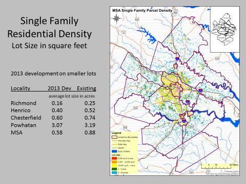
Land use: From the individual parcel, all the way up to the entire region and updated annually from each local government’s development records. It is open space, forested, agricultural, single-family detached housing, multi-family, office, shops, manufacturing?
Employment: Beginning with an annually updated database that includes each business in the region, we sort and present businesses and their employment by industry and location, suitably aggregated to preserve confidentiality, but providing far more information than is typically available from other sources.
Population: Using decennial Census counts and updates and estimates for the intercensal years, we provide numerous characteristics on the population, including household size and income, at the Census block group level of detail.
Infrastructure: Streets, roads, highways; water, sewer and electric utilities.
Public facilities: Schools, parks, government buildings and amenities, etc.
Environment: Green infrastructure and selected environmental characteristics.
Government Plans: Comprehensive plans and zoning.
Using Metro View’s interactive website, viewers can choose the level of geography that interests them. They can take a truly “metro view” that cuts across local-government boundaries, they can drill down to a single neighborhood or they can create their own area of interest. They can then query the databases listed above — choosing any combination they wish — to create a profile of their area. In this way, they can pose and answer a virtually limitless number of questions, such as:
- Where is new housing being constructed in the Richmond metro area? What kind of housing is it — single-family detached, multi-family?
- How much land per dwelling unit does new housing use?
- Is new housing closer to jobs than existing housing, or farther away?
- Where in the metro area is there vacant, developable land? At what cost?
- Where is poverty concentrated in the metro area?
The Metro View website can be accessed at metroview.vcu.edu.
CURA @ VCU staff will also undertake customized research projects that answer important policy questions, such as:
- How can the region achieve a healthy balance of jobs and housing?
- Are the land uses on the boundaries of local jurisdictions mutually compatible, making an efficient pattern, or are they conflicting, creating hassles?
- Where is the most affordable housing in the region? Is it located close to transit or major corridors?
- Which neighborhoods provide the best access to amenities and services for seniors – whether in the same political jurisdiction or in another one? Where are seniors isolated from services? How can this be addressed?
- Is the Richmond MSA becoming a “region of short distances,” or are we traveling ever-longer distances to access the things we want and need?
The “social” component of Metro View consists of several features:
Metro View Website: Described above.
Metropolitan Observer: Quarterly digital publication (with limited hard-copy circulation) that highlights results of the Metropolitan Development Tracker, synopses of analyses by academics, and opinions by regional leaders on metropolitan growth and alternative public-policy responses.
Metro Poll: Annual or bi-annual poll of citizen attitudes about metropolitan development issues.
Metro Forum: Annual region-wide discussion of metropolitan development issues.
Metro View reports and projects
First Annual Report of the Metro View Development Tracker (2015)
Supported by VCU Presidential Quest Fund and Wilder School of Government & Public Affairs
Detailed description, mapping and analysis of development as of 2013 at the individual parcel level of detail for the entire Richmond Metropolitan Statistical Area, plus several counties on the fringe of the MSA.
Second Annual MetroView Development Tracker (2017)(2017)
MetroView Development Tracker provides a snapshot of land use, property value, development footprint, and jobs-housing balance as of 2014-2015 for 15 counties, 6 independent cities, and one town comprising the greater Richmond metropolitan area.Detailed land use profiles for the RRPDC and Crater PDC boundaries and for individual county/city are also included in the report.
Mapping Senior Access and Isolation in the Richmond Region
- A Pilot Study and Analysis (2015)
Client: Greater Richmond Age Wave Coalition/United Way of Greater Richmond
Analyzes and maps the Richmond region in terms of the proximity of senior citizen residences to retail, health care and other services that seniors need. Seniors and services are somewhat concentrated in Richmond and Henrico, but many suburban and rural areas have concentrations of seniors but few goods or services nearby. At the neighborhood level, access via walking is analyzed in the Willow Lawn and Libbie-Grove areas.
A Program Targeting Model and Impact Analyses (2015)
project:HOMES
Creates a dynamic model to enable project:HOMES to determine the need for its Rehabilitation and Weatherization services within any census tract location in the Richmond Metropolitan Statistical Area. Need is greatest in mature cities in the core of the MSA, as well as in outlying rural counties.